
Posted at 01/03/2014 10:54 AM
 |
| Kapurpurawan Rock Formations in Burgos, Ilocos Norte. Wikimedia Commons |
PHIVOLCS Earthquake Bulletins of latest seismic events in the Philippines (in Ilocos Norte and nearby areas for this purpose). The event parameters (hypocenter, time and magnitude) are determined using incoming data from the Philippine National Seismic Network
Philippine Standard Time (PST) is eight hours ahead of Coordinated Universal Time (UTC). (PST = UTC + 8H) UTC is the time standard for which the world regulates clocks and time.
Earthquakes in this list with their date and time underlined in blue have reported felt intensities. Intensity ratings are based on the PHIVOLCS Earthquake Intensity Scale
Date - Time Latitude Longitude Depth Magnitude Location
(Philippine Time) (ºN) (ºE) (km)
(Philippine Time) (ºN) (ºE) (km)
03 Jan 2014 - 10:48 AM 18.84 120.17 014 3.1 062 km N 55° W of Burgos (Ilocos Norte)
03 Jan 2014 - 03:30 AM 19.23 120.16 033 4.7 094 km N 33° W of Burgos (Ilocos Norte)
03 Jan 2014 - 03:30 AM 19.23 120.16 033 4.7 094 km N 33° W of Burgos (Ilocos Norte)
03 Jan 2014 - 03:02 AM 19.22 120.30 021 4.9 087 km N 26° W of Burgos (Ilocos Norte)
03 Jan 2014 - 12:37 AM 19.13 121.19 020 3.3 035 km S 60° W of Calayan (Cagayan)
03 Jan 2014 - 12:00 AM 19.17 120.11 034 3.3 093 km N 39° W of Burgos (Ilocos Norte)
02 Jan 2014 - 09:03 PM 16.54 122.18 010 3.1 009 km N 80° W of Dinapigue (Isabela)
01 Jan 2014 - 09:26 AM 19.15 120.06 018 4.3 107 km N 41° W of Burgos (Ilocos Norte)
01 Jan 2014 - 08:01 AM 19.11 120.04 023 4.3 094 km N 46° W of Burgos (Ilocos Norte)
01 Jan 2014 - 07:41 AM 19.20 120.18 023 4.8 091 km N 33° W of Burgos (Ilocos Norte)
01 Jan 2014 - 05:45 AM 19.22 120.18 017 4.3 094 km N 33° W of Burgos (Ilocos Norte)
01 Jan 2014 - 05:32 AM 19.14 120.15 067 4.3 089 km N 38° W of Burgos (Ilocos Norte)
01 Jan 2014 - 04:01 AM 19.23 120.02 040 5.5 105 km N 41° W of Burgos (Ilocos Norte)
31 Dec 2013 - 01:46 PM 19.06 120.23 012 3.3 075 km N 36° W of Burgos (Ilocos Norte)
31 Dec 2013 - 11:29 AM 16.77 120.60 034 2.8 034 km N 61° E of San Fernando (La Union)
31 Dec 2013 - 04:31 AM 19.15 120.34 034 4.0 077 km N 24° W of Burgos (Ilocos Norte)
31 Dec 2013 - 04:17 AM 19.17 120.16 035 4.2 089 km N 35° W of Burgos (Ilocos Norte)
*** *** ***
Planetary Alignment/Earthquake Watch January 6-10, 2014
| Planetary Alignment/Earthquake Watch January 6-10, 2014 |
Three very strong Planetary Alignments (Sun-Earth-Jupiter on January 5),
(Sun-Venus-Jupiter on January 7) and (Earth-Venus-Sun on January 11) combined with
the Earth reaching Perihelion January 4 along with strong Lunar astrological aspects may
foreshadow a potential for one or two earthquakes over 7.5 Magnitude for:
Southeastern Alaska, Gulf Of Alaska or Alaskan Peninsula
Time Frame January 6-7 ( Magnitude (7.2-7.5) Honshu Japan, Kuril Islands or Hokkaido Japan Time Frame January 9-10 (Magnitude 7.5-8.0) SolarWatcher *** *** *** Big Sunspot shot from the Philippines
BIG SUNSPOT, CHANCE OF FLARES: Sunspot AR1944, which emerged over the sun's
eastern limb on Jan. 1st, is big and potentially dangerous. The complex region contains more
than a dozen dark cores, and the leading spot is big enough to swallow two planet Earths all
by itself. AR1944 is so large, sky watchers on Earth are beginning to notice it as a blemish
on the solar disk at sunset:
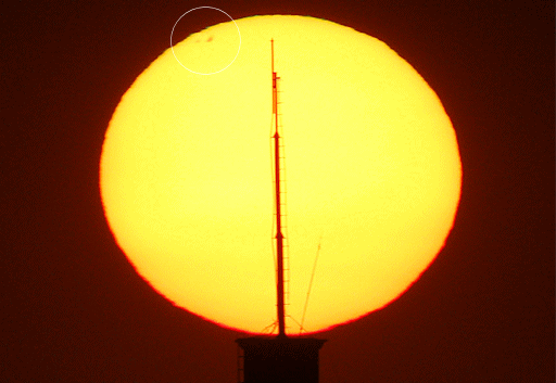
"This was my first sunset shot of the year," says photographer Raymund Sarmiento of Quezon
City, the Philippines. "AR1944 is circled. That sunspot has the potential to disrupt
transmission/reception of radio signals on the foreground antenna." SpaceWeather
|